Time to stir the mud and draw up some controversy….
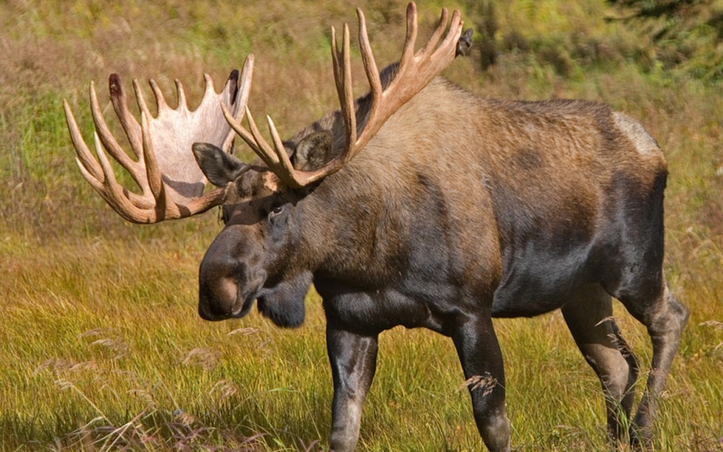
It’s at this time of year that I start getting that itch to hike in the hills and look for large brown moosies. I want to fill my freezer with meat that I know was raised right and is healthy for my family! I was raised on moose meat and I have strong memories of my dad going hunting every fall in Soldotna, AK. I remember as a young person, spending the night at a friends house and wondering why their meat tasted like cardboard. I later found out that it was store bought beef and it was very bland compared to the moose meat that I was used to.
As we move closer to the hunting season, I have the urge to buy a gun, ammo, meat bags, 4-wheeler, and a trailer. I get the urge to secure any item that will help me fill that freezer with healthy moose meat. I know this is not your typical girlie behavior but that is what happens when your raised in Alaska. I remember helping my mom and dad cutting meat off the carcass, cleaning it, wrapping it in freezer paper, and marking it with the date, type of meat, and the cut of the meat.
This is basically what a package of moose meat might look like.
Two years ago, we got two caribou and those really helped us to eat right and cut our grocery budget over time. With meat prices going up at the stores, it’s really worth it to spend a little to catch that elusive moose. Yet, moose are one of my favorite animals to watch and photograph and I highly respect those animals. I believe that farmers feel the same way about their cows. If you know how it has been raised, then you know your eating well. You respect the meat that you are eating.
My husband, an Alaskan Native from the Kuskokwim River region, finds it difficult to hunt in the South-Central area of Alaska. Where he grew up, they would climb into the boat and head upriver, usually up the Holitna River, and find a moose hanging out on the edge of the river. Sometimes they were lucky enough to not have to drag it out of the waters edge or chase it too far into the woods. Sometimes they had to work a little bit harder. Lately, though, the people out there are having a difficult time getting anything due to the amount of wolves and bears in the area.
Sleetmute, Alaska. You can see at the top of the picture that the Holitna River (left-top) flows into the Kuskokwim, which comes from the left-middle side. They run south around an island at the bottom.
In many areas of Alaska, there has been a growing problem with bears and wolves. I will go so far as to say that there is a growing problem with predators in Alaska, humans included. If you think about it, there is now a situation where people from outside specific hunting areas are coming in and hunting for moose. This depletes the already stressed population of moose in those areas. For instance, on the Kuskokwim River, you have an area in the upper river region that used to have a healthy population of moose. Then the lower river people from the ever growing city of Bethel come up to hunt moose and you have a higher amount of “predators” in that area. Then there are hunters that are being flown in from other parts of the state and from out of the state. Add to that the growing population of bears and wolves, and you have a problem. This same situation is affecting the caribou in that very same region.
Imagine a population of moose in a particular region that are already hampered by a growing population of wolves and bears. Now imagine this population is accessible by road. Think about how many people are reaching this region from hundreds of miles away and maybe thousands of miles away if they are non-resident hunters. I bring to light the Copper Valley region of Alaska. The people there have never had such difficulties hunting moose until recently. They are now in competition with the rest of the state and with many from out of the state of Alaska. Most of the “outside” hunters have access to ATV’s and large hunting buggies. They may have RV’s or travel trailers to sleep in. The local hunters do not have a lot of these available to them. With so many ATV’s and other traffic hitting the trails, the moose are being pushed back further and further into the wilderness, to the point that only ATV’s or fly-in hunting can reach them. They also have a huge population of bears and wolves, common predators of the moose and caribou. This leaves many locals without meat for the winter.
Sorry, this is graphic but it’s the truth. More and more calves are killed by wolves and bears each year adding to our declining moose population.
Now don’t get me wrong, I am not against hunting. In fact, I am a strong advocate of our rights to hunt and feed our families and I support the NRA. But I am also witnessing something that I am not in support of. I do not think that our population of moose should support non-resident hunting and especially since many of those hunters are only after the “rack” and could care less about the meat! I realize that many people make their money by being a guide but that is a profession that is self-defeating. You will see such a large decline in the moose populations that there will be none left for anyone. I believe that trophy hunting should be abolished! Hunting for meat and getting a “big one” is different than just hunting for the rack on the wall and I have seen many who do that very thing.
I am seeing this same thing with our salmon. You see many folks up here fishing for that trophy and not caring about eating any salmon. I see that our commercial fisherman are fishing to earn enough money to feed their families but at the same time, they are fishing to feed the world off of fish that should merely feed Alaskans. And our world population is growing. Are we going to feed the world salmon that was meant only to feed a smaller population of Alaskans? Are we going to try to give a trophy salmon or moose to the world so that they can feel proud of themselves while Alaskans go hungry and eventually have nothing left to hunt or fish?
In the Kuskokwim and Yukon Rivers, there is a growing problem of the local natives not being allowed to catch salmon. How much salmon were caught by commercial fisherman? I do not know this answer. You can look into that for yourself. But know this, they were there first, they have always been there, and now they are being told that they cannot fish. This means they cannot feed their family. There are declining moose and caribou populations, and now a declining fish population. Recently, there have been battles by the locals out there for them to fight for their rights to fish. It is a bad situation all around. They do not want to see the fish decline but they want to feed their family too.
Again, let me reiterate, I am not against hunting or fishing. I am against mismanagement of such. I am seeing different regions of Alaska trying to support a growing population of hunters and fisherman. I am seeing that they cannot support this. I am seeing us trying to feed the world and we cannot do that. Lets bring to light the beloved dip-net fisheries in Alaska. We are seeing a growing outrage from those regions about the demise of their beautiful beaches and there is another problem.
Let’s look at the dip-net fishery in Kenai, AK. I grew up in Soldotna, which is the nearest town to Kenai. I remember a few dip-netters on the beach in the 80’s but I could literally count them on one hand at any given moment. I could still walk the beach and not step on a salmon carcass or be pooped on by a seagull. Now, flash forward, the beach is so encumbered by fish carcasses that it would take you half an hour to clear enough space to set your chairs and equipment down. The smell? Well, lets just not discuss the smell as I just ate breakfast.
Kenai dipnetting in 2009. You see salmon carcasses all over the beach.
Seagulls are everywhere, clouds of them. This is the problem. The dip-netters are gutting the fish on the beach and that attracts gulls which causes them to litter the beach with their feces. This has recently caused a problem with a bacteria on the skin of the salmon and a warning about making sure to clean them good. The people of the region are upset, and for good reason too! They have to go clean up after all the dip-netters and it’s not a fun job. Why should they have to do that? They are accommodating people from outside their region and they are suffering.
Can the Kenai dipnetting fishery support this many people…plus the rest of the world?
I am hoping that you are getting my point. Can I find any fish in my local area (Matsu Borough)? Maybe. Not really without a boat or other equipment. Many rivers have been closed to fishing. Have I been to other regions to try to fish or dip-net. Yes. Guilty. Do I catch much? No. I gave up dip-netting years ago after seeing its affects on the beaches and the locals. Do I have any fish in my freezer? No. I am not a great fisherman though, so that is part of my problem. But the same goes for hunting. I find it very difficult to hunt for moose because there are so many ATV’s and hunting buggies; and then there are the hunting regulations that are very confusing. I do not have a “healthy” ATV and it struggles to get very far. It’s a case of drive one mile then work on it for one or more hours, sad to say. I cannot afford a new ATV nor can I afford a hunting buggy.
I want to fish and put salmon in my freezer, but I don’t want to hamper the fishery or put another region into stress. I want to hunt and fill my freezer with meat, but I don’t want to be part of the problem for another region and cause its locals to not be able to eat. Can I hunt locally? Well, that’s a good question. I am trying and, so far, not doing so great with it. I see both sides of the story and am hoping that we can find some answers to this situation. I would like to find some sort of answer to this problem but I am only one person, and it is going to take everyone working together to communicate and understand. So let’s get to work and figure out how to feed the people of Alaska first; giving the locals a better fighting chance to provide for their families.
In the meantime, shhhhhhhhhh……….I’m hunting moosies!!!
The ghost town of Kennicott and the copper mine named Kennecott up on the hill.
Kennecott is the name of the mines and company, while the glacier and town are named Kennicott after a local explorer by the name of Robert Kennicott. The mines and company were misspelled due to a clerical error. After the green streak in the mountain was discovered, the next step was to get it out of the back country of Alaska. They ended up mining some gold in the area to fund the building of the railroad to the copper streak. That green streak was one of the richest copper ore deposits ever found!
McCarthy is the name of the creek and the town that popped up below the mine due to the “dry” Kennecott mine not allowing gambling and or other assorted affairs. Today, the mine is a ghost town that is being restored and McCarthy has a winter time population of between 15-20 families. They say that the population is rising due to the tourism in the summer. The McCarthy road from Chitina to the mine is closed in the winter but you can use snowmobiles to travel the 60 miles or use the airport.
The Kennecott Mine up on the hill above me. You can only go in this building with a guided tour.One of the many buildings that are still standing after 100 years.There was a flood that destroyed some buildings in this area and you can really see the signs of the years.
Construction of the railroad to the mine began in 1908 and stretched 196 miles. The current McCarthy road is built over top of most of the old railroad. For 27 years, the railway carried a staggering $200 million in copper ore from the historic Kennicott mining area to the coast of Cordova. The last train delivered the very last load of copper ore on November 11, 1938. During the 1964 earthquake, with a magnitude of 9.2, the railway was destroyed and never rebuilt. Kennicott has been a ghost town since then and, in 1978, President Jimmy Carter declared the area a National Monument because of its cultural and scientific significance. They are now part of the Wrangell-St. Elias National Park & Preserve. At 13.2 million acres, it is twice the size of Denali National Park and larger than the country of Switzerland. It is home to 9 of North America’s 16 tallest peaks, over 150 glaciers, 4 major mountain ranges, and the largest glaciers outside the polar ice caps.
McCarthy and the Ma Johnson’s Hotel. My kids walking the wet streets. Those are permitted vehicles only.I found it interesting to see the blending of the old with the fairly new in this photo. Notice all the bikes on the right.This is a gently restored hardware store that was being used to house the live band for the McCarthy Whitewater Festival that was going on during the weekend that we visited.
Today, instead of the tram that was used to pull yourself across the river, they have a foot bridge. There is a bridge down a ways that only permitted motorists can use to cross the river and those are usually only the locals or deliveries. Once on the other side, you can choose to hike the short distance to the small base town of McCarthy or you can take the shuttle. You can also skip McCarthy and just head straight up to the mill town of Kennecott. The shuttle to McCarthy is free but the ride to Kennecott is $10 for a round trip and they will give you a little ticket for your return trip. It is a 5-mile hike and so worth the shuttle ride, because you will want to save the hiking for the trail to the glacier or up to the mines. Another good option is to bring a bike and I highly recommend it as many people bike in the area.
The footbridge that leads across the river. I am standing on the McCarthy side of the river after getting out of a shuttle. Our vehicle is parked in the lot on the other side.
For accommodations, there is the Kennicott Glacier Lodge (http://www.kennicottlodge.com/) that is right on the mountain and within the old mining town itself. It is a restored building so expect the rooms to reflect that. Another option is to stay at the historic hotels within McCarthy. You have the McCarthy Lodge and The Ma Johnsons Hotel (http://www.mccarthylodge.com/) with many services available nearby. On the road side of the foot bridge, you will find many campgrounds, Bed & Breakfasts’, Lodges, and cabins nearby. We stayed at the Kennicott River Lodge (http://www.kennicottriverlodge.com/) in one of their cabins that could accommodate 6 people and a dog. We were very glad that we did and found that they are extremely accommodating and had all the services that we could possibly want. We had a great view of the glacier, mill town, and a glacier lake in the foreground.
Our cabin that somehow accommodated all 6 of us plus a dog. Believe it or not, there was a loft with 2 twins that pushed together for my hubby and I, and 2 bunk beds (4 beds total) on the main floor with a couch that pulls out. http://www.kennicottriverlodge.com/
One of the things that I found confusing, beyond the spelling of the Kennicott/Kennecott names, was whether the glacier was called the Root Glacier or the Kennicott Glacier. Well, it turns out that there are two glaciers in the area which explains all of the dirt, ice, and water that flows beneath them. The glacier actually closest to the mine is called the Root Glacier and beyond that, and partially connected, is the Kennicott Glacier. You can hike both if you are of able body. They have hiking tours (http://kennicottguides.com/ or just google Kennicott guides) available for the cost of a guide and cramp-ons for your boots. We didn’t have a guide and we chose to just hike to the Root Glacier for a shorter experience since we are amateur hikers.
This is my nephew Mike, youngest son Jakob, and my daughter Katerina. My oldest son Billy and his dog were way ahead of us on the trail. They were much faster hikers. About half of the trail was in this condition, which was fairly nice.My nephew Mike and my youngest son on the knoll of the moraine near the Root Glacier. You can see two hikers on the trail leading to the right. The rocks slid a lot but the knoll is where we ended up eating lunch.On the left, on the toe of the Root Glacier, you can see my oldest son Billy and his dog Boo. You can also see a guided tour heading out onto the glacier. The guide helps them put on cramp-ons and schools them on how to walk on the glacier.You can see my oldest son Billy and my nephew Mike walking down from the edge of the Root Glacier. Very nerve-wracking for a mom.The beautiful Jumbo Creek. I recommend taking a rest here if possible before you hit the rough terrain beyond the falls. Very refreshing as a return rest too.
The trail to the toe of the Root Glacier is around 2 miles and most of it is a fairly easy hike. There is the last 3/4 mile of the trip that is down hill and partially in the moraine (http://en.wikipedia.org/wiki/Moraine), so you can expect sliding rocks and some of it is a strenuous hike. I found it even more difficult coming back up out of there. Now if you are used to hiking and are used to mountain climbing, you might get a slight laugh out of my version of strenuous. I am an asthmatic so it made this hike a bit more difficult for me as I have not been hiking much this year. I did have to use an inhaler on several occasions during the hike, sad to say (Just a warning for those in my current condition.) The hike is worth the pain!
This is a view from the front deck of our cabin. You can see the Root Glacier on the left (very rainy at that moment), the Kennecott Mill just to the left of the tree, and the glacier lake with little icebergs in the foreground on the right of the tree. McCarthy and the foot bridge was further to the right.
There are a few beautiful creek crossings, some wonderful views of the glacier and surrounding mountains, and the exhilaration of completing the 4 miles round trip is so very worth it. The glacier was beautiful but ended up not being my most favorite part, although the kids loved it. Jumbo Creek, and its waterfall that you cross, was my most favorite part of the hike. Making it back to Kennicott and saying “Wow! I made it!” was a really great feeling for me. I pushed myself and, while most hikers would find it a casual hike, I felt accomplished. I now know that I need to hike more often and condition my body for what I really want to do because there is nothing worse than your mind saying “I want to go see that!” and your body replies “oh…there is no way that is happening!”.
My daughter, Katerina, and my ponytail. 😉 You can see where we are eating lunch. We are facing the glacier but you can see the trail that we arrived on and all the rocks that we slid around on.Kuskulana River Bridge: one lane, no stopping on the bridge! Have fun looking down but be careful and stay on the bridge. You can explore under the bridge too!A view from underneath the Kuskulana Bridge. My kids climbed around on a ramp that walks across with rails. I couldn’t get up on there because the climb is a steep jump up on concrete.
Kennicott, McCarthy, and the Root Glacier are worth the 60-miles (on a dirt road) road trip and worth seeing if you see nothing else in Alaska. You must have a spare tire and a tire repair kit if you attempt this trip in your vehicle, although I have never had a flat. The old railway spikes have a tendency to come up to the top of the road from time to time. I have seen little front wheel drive cars, as well as RV’s, make this trip with no problems whatsoever. You will also cross the single lane Kuskulana Bridge over Kuskulana River Canyon that is around 525 feet across and 238 feet above the river. Take plenty of pictures of this historic bridge and enjoy the mesmerizing views! Make sure you have plenty of gas as the last gas available is in either Kenny Lake or Chitina. Also, make sure you have plenty of room on your camera or smartphone for lots of pictures. Have a great trip…we sure did!!!
Getting reservations for a large family, with a dog, is harder than it seems. No matter the location, I find it difficult to gain accommodations that would suit all 6 of us, plus the dog. This is our family: One dad, one mom, one 12 year old son, one 17 year old son, one 18 year old daughter, one 20 year old nephew, and our dog (large breed.) Now one would think that Alaska has a lot of larger families and thus would have accommodations to compliment that knowledge; however I am finding the opposite to be true.
Hotels are most likely out of the question unless I am willing to rent several rooms in a dog friendly hotel. On a few occasions, I have found hotels that have full suites available but most often they do not like pets. I must say there are a few out there and I greatly appreciate their thoughtfulness to accommodate larger families. I am even more grateful when I see that it is very clean and there are no bed bugs in the establishment.
Some B&B’s might be willing to accept a larger family but I have found that they most often do not accept pets. I have never been able to stay at a B&B due to our family size and the pet issue. That being said, I have always wanted to stay at one and have always admired those who run them. It is a lot of work and dedication to open one’s home to the general public.
Motels generally do not seem to care how many people will be staying in the room and will usually rent it to you without question. More often than not, they will allow pets; however they frequently smell musty and are sometimes dirty. I have also found bed bugs in many motels and that is something I never appreciate.
Cabins are usually a better bet but you have to find one that can accommodate so many people. I have been lucky enough on many occasions to find cabins that can house 6 people comfortably and it is usually a 50/50 chance that they will allow a large dog. My family prefers the cabin style rentals due to the privacy that they afford, but that is only if they have decent bathroom availability. Some have outhouses and that is okay…IF they are clean!
Lodges are usually out of the question for large families with pets due to the very nature of a lodge. It is usually on a more grand scale and most often related to some sort of fishing or hunting adventure. Where would you stash your dog on a fishing trip anyhow? But, again, I am sure there are some out there that might allow large families and pets with the usual “fees” tagged on top of it.
That brings me to the other part of our dilemma. Fees! Families are usually looking for savings on their trips due to the very nature of the cost of a family to do anything beyond just existing in day to day life. So when I go to websites and they say “double occupancy + $25 for each additional person + $75 pet fee”; let’s just say I cringe and keep looking elsewhere. The additional fees that go beyond the double occupancy, plus the pet fees, taxes, and meal expense make it very difficult for families to do anything together. It seems like the lodging industry is just out to make a buck on the larger families instead of being understanding and accommodating them for the same price in the same room or cabin as a smaller family. Does it seriously cost $25 extra to do the laundry of towels and blankets for each additional person?
I wanted to write about this subject because I know that many other families are out there and have situations just like mine. Maybe someday soon, all my kids will leave the nest and it will get better but we have been dealing with this for a very long time. It’s frustrating to say the least and I am hoping that someone, somewhere, will read this and realize that larger families need to get out and have fun too! For the most part, we have stuck to campgrounds and tents but this is Alaska! We don’t want to camp every single time and some places are very cold at night. Our summers are short and there are seriously a lot of mosquitos in most areas of Alaska. If you have a large family and have dealt with this situation in your adventures, then I totally understand your frustrations.
I planned a nice little camping trip to the Kenai Peninsula for the 4th of July. We were traveling from Palmer, Alaska about 260 miles south to Homer, Alaska; which is about a 5 1/2 hour trip if you don’t stop much. On our way out of the Anchorage area, we stopped and got something to eat at Village Inn for dinner. We did this because we were leaving right after the guys got off of work and just packed up and headed out.
I did not reserve any camping spots as I wanted to “wing” it. This was sort of a test of which campgrounds get the most traffic on the 4th of July. I will have to say that MOST of the campgrounds were jam-packed with 4th of July campers and any empty spots usually had reservation tags on their posts. I don’t mind primitive camping but we hoped to find one with a bathroom due to so many in our group. We had my husband and I, our 18 year old daughter, our 17 year old son, our 12 year old son, our 20 year old nephew, and our large dog.
Our campsite at Morgans Landing.The view from our campsite in Morgans Landing.
We did find a great spot for the first night on July 3rd at Morgan’s Landing in Sterling, Alaska. This area is just outside of Soldotna and, since it was well off the highway, it was very quiet. After passing the Moose River on the other side of Sterling, you will find the signs that point to Morgan’s Landing State Recreation Area. This campground has 51 campsites and they are $10 per night. There are many pull-throughs for RV’s and trails that lead down to the Kenai River. This was a very quiet campground, the bathrooms were super clean, and the mosquitoes were moderate. We got in very late and had to very quietly set up camp.
After having breakfast (eggs and bacon) we broke camp and headed south towards Homer. We checked out a few campgrounds on the way down but realized that we must avoid the Kasilof River area due to the heavy amount of dipnetters in the area. Dipnetting is an Alaskan subsistence way of getting fish and it is allowed in only a few rivers.
So, heading past the Kasilof area, we ventured closer to the Ninilchik area. Ninilchik is a Russian Village from back in the days of the purchase of Alaska. They have an old Russian Orthodox church which is a popular stop for tourists and the village has some stores and gift shops that you can visit. We liked the area for the beach access. But we decided to move on and check out the other areas closer to Homer.
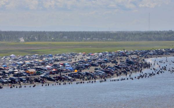
Just before reaching Homer, you will want to stop at the top of the hill and check out the view of the Kachemak Bay and the Homer Spit from up above. It is a popular stop and a must see photo opportunity. And then driving down into Homer, you will just stay on the road to head right down onto the Homer Spit. This is also a must see and is most definitely a popular spot on the 4th of July. The spit was super packed and it was honestly a bit unnerving trying to dodge all of the people crossing in front of you. All of the camping sites were over-full and so we just walked around and had some ice cream at one of the little shops.
Above Homer, Alaska. What looks like a little gravel bar on the very left side of the water is actually the Homer Spit. It has camping, shops, restaurants, hotels, and more on that tiny little spit.
We ran around Homer for a little bit and then decided to head back towards Ninilchik for the night. We would have rather camped in Anchor Point on the Anchor River but all 5 of their campgrounds were packed full also. Note to self: Get reservations at the Anchor River Campgrounds ahead of time as it was gorgeous there! Now back to the Ninilchik River Campground.
Luckily, the campground was not completely full, even for the 4th of July. The Ninilchik River Campground was based not too far away from the Ninilchik River, the beach access road, and the village of Ninilchik. The campground was $10 per night and there was no host but a park ranger drove through twice. We had BBQ Chicken and baked sweet potatoes for dinner. It was a nice quiet campground but you could still hear the highway vehicles. We weren’t the most quiet campers though, as we had brought those celebration pop-its that you can buy at the store and the kids had a blast with those.
This is the campsite we chose in the Ninilchik River Campground. Lots of space for our 3 tents!
On the night of the 4th, you could hear fireworks being set off in the nearby village. And then the next morning, I heard the Alaska State Trooper pulling over vehicles on the highway. But all in all, this campground was fantastic! There were very few mosquitoes and the bathrooms were very clean.
My daughter and my husband on Ninilchik beach with our dog, Boo. You can see one of Alaska’s volcanoes in the background. There are several across the Cook Inlet from this area.
On the morning of the 5th, after a breakfast of corned beef hash and boiled eggs, we headed over to the beach and spent some time wandering around and enjoying the slight breeze that had rolled in. After spending the morning on the beach in Ninilchik we decided to head back over to the Anchor River for some lunch (sausage dogs and mandarin oranges) and a little trout fishing. That was a great call and we had an awesome picnic lunch there. We didn’t catch anything but there were some small fish running all around the boys while they played in the water.
A view of the Anchor River and the giant Cottonwood trees that stand over it.My husband, Stefan, was fishing for trout in the Anchor River, but they also have salmon.The 3 musketeers! Mike, Jakob, and Billy. They walked the plank to the big rock. In the background on the other rock, you will see two seagulls and their nest right in front of them.Wild Geraniums are growing all over the riverbank of the Anchor River in Anchor Point, Alaska.
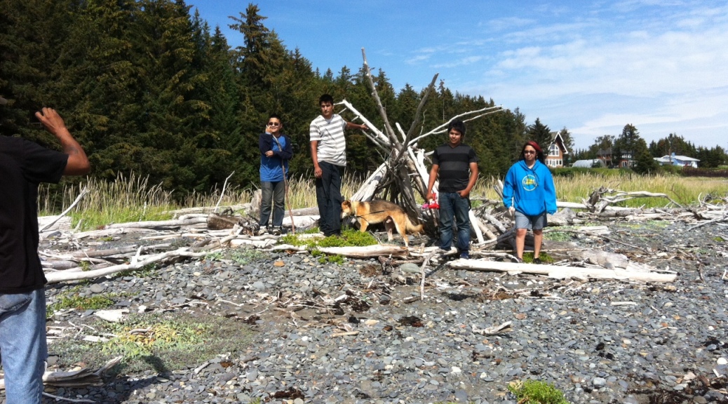
That afternoon, we decided to head back to Homer to check out Bishop Beach. That was a great call as we hit the area at a perfect low tide. The kids all enjoyed running around the tide pools and checking out all of the little critters under the rocks and we found a ton of shells. It was a bit windy as there was a rain system moving in. But all in all, it was a great time and one that the kids will remember for a very long time. Totally perfect day!
All 4 kids standing next to a driftwood teepee that they found on Bishops Beach. You can see a bit of my hubby on the left.The kids were checking out the tide pools and flipping rocks to see what sort of critters they could find. They found a lot of really neat creatures! My daughter, nephew, and son.The water was cold but my daughter couldn’t resist taking off her shoes and enjoying the ocean!The view of the City of Homer and our vehicle on Bishops Beach.
As we headed back to our camp in Ninilchik, we noticed a large amount of clouds moving in and the wind started to feel cold. We made our dinner (hamburgers) that evening in camp and discussed whether we wanted to spend another night with a chance of breaking camp in the rain in the morning or just pack up now and make the long 6 hour drive home that night. We decided to break camp and drive home that night. We were glad we did that as we woke up the next morning to a rain storm outside and we knew that we would have been soaked while taking down the camp.
We are packing up our rig to head back home. We had to fit 6 people and a dog in it so we had packed most of our stuff into totes on the top and strapped them on to the sports rack!On the Seward Highway not too far away from Summit Lake. You can usually find odd cabins in oddball places like this along the highway.
Well, that pretty much sums up our 4th of July trip and the fun that we had on the Kenai Peninsula. 🙂 I hope that you enjoy the pictures that I have posted within my narrative and if you are ever in Alaska for the 4th of July, please remember to make your reservations ahead of time for any campgrounds that you may want to stay at.
This recipe is really delicious and I recently added it to my Alaskan Foodie blog. I love stuffed bell peppers and I have tried so many variations, but this one is my favorite! Take a peek and see just how good moose meat can be!
Actually, the highway is called the George Parks Highway, but it is more commonly known as just the Parks Highway, or Alaska Route 3. This 327 mile highway runs from a junction with the Glenn Highway about 35 miles north of Anchorage to Fairbanks. It has been designated a National Scenic Byway and it is also considered an Alaska Scenic Byway from about Mile 132 to Fairbanks.
This highway runs right through the Denali State Park and on the edge of the Denali National Park and Preserve. Mount McKinley, which is locally called Denali (elevation 20,320 feet), is viewable from several points along this highway. It is typically about a 6 hour drive, unless you stop and see the sights like we always do. There are several stops and side trips along the way that will draw your interest for sure.
In this article, I will be pointing out the campgrounds and RV Parks that include tent camping, mostly because a large multitude of the campgrounds are privately run on this highway. Otherwise, I will not post the private businesses. For a complete, mile-by-mile, listing of this highway and all of the RV parks and much more, I highly recommend The Milepost (www.themilepost.com). I will include some points of interest near each camping site whenever possible too. I will start this list at the Glenn-Parks Junction and continue up the Parks Highway to Homer.
For the ease of writing, I will only post the mileposts heading North (N). I will also put a (+) sign if it is within the mile marker; for instance, if the location is at mile 44.4, I will put 44+. You can assume that all campsites have a fire-pit, toilet, and table; unless I claim that it is primitive. Please watch for bears in the campgrounds and moose along the highway. So come along and go camping with me!
Mile N 0 – Starts at mile 0 in Anchorage.
Mile N 35 – Glenn-Parks Interchange: The sign heading north indicates that the Glenn Highway ends and the Parks Highway begins. Thus begins Alaska Route 3.
Mile N 36+ – Exit to Trunk Road: This newly completed road will take you to not only the hospital but also the Mat-Su Visitor Center and Veterans Monument. It will also eventually take you to Finger Lake State Recreation Site.
If you travel down Trunk Road to Bogard Road and go through the roundabout heading west down Bogard (left); you will find the Finger Lake State Recreation Site at mile 6.6 Bogard Road. This park has 39 campsites with wheelchair-accessible toilets, water, and boat launch.
Mile N 42.2 – Junction with Main Street/Wasilla Fishhook Road & Knik-Goose Bay Road: This confusing intersection throws many travelers. Heading North, is Main Street which turns into Wasilla Fishhook Road within a few blocks (at Bogard Intersection). Wasilla Fishhook heads toward the hills and junctions with Palmer Fishhook Road, which heads northeast to Hatcher Pass Road and Independence Mine State Historical Park or south towards Palmer (see more about Hatcher Pass at Camping on the Glenn Highway [coming soon]). If you take Knik-Goose Bay Road, instead of Main Street, you will head towards Point Mackenzie and it’s a nice side trip.
My family at Hatcher Pass.
About 2 miles in, you will find the main entrance for the Iditarod Trail sled Dog Race™ Headquarters and visitor center. Just after that turnoff is Endeavor Street and about ½ a mile down that road is Lake Lucille Park (managed by the Mat-Su borough) campground and day use area. This campground has 59 sites, picnic pavilions, water, restrooms, playground, and trails at Lake Lucille.
At about 13 miles in, you will come across Knik Historic District which has a private campground on Knik Lake. (I have heard recently that this campground is for sale, so am not sure if it will be open for a little while.)
At just over 17 miles in you will find a junction with Point Mackenzie road. Follow this road for about 7 ½ miles and you will come to a “T” junction. If you turn left, you will head out to Point Mackenzie; if you turn right, you will head towards Susitna Flats State Game Refuge. We will head right from here and follow the road around the bend to the left.
At about 10 miles in, you will come to a fork in the road (after passing some railroad construction); take the road to the right. Then about 3 more miles in, you will come to the Little Susitna River Public-use Facility. You will find 40 campsites, outhouses, boat ramps, water, and great fishing. Please watch for bears and bring extra mosquito repellent.
Return to the Parks Highway at Mile 42.2 and continue north.
Mile N 52+ – Junction with Big Lake Road: Taking Big Lake Road will bring you into a resort destination for most Alaskans. In the winter, the lake has roads graded into it and they usually have snowmachine races and such. In the summer, you will find boaters and ATVs. There are three state recreation sites in the area that include swimming, camping, boating, fishing and much more.
At a little over 3 miles in, there is a junction with Beaver Lake Road. You can take this road to visit Martin Buser’s Kennels and Rocky Lake. Follow the signs to Rocky Lake State Recreation Site with 12 campsites on a gravel loop road with outhouses, water pump, and boat launch. (Lake is closed to jet skis, jet boats, and airboats)
At about 3 ½ miles on Big Lake Road, you will come to a “Y”, which is a junction with North Shore Drive. Take a right (North Shore Drive) and follow it for 1 ½ miles to the end at Big Lake North State Recreation Site with 60 overnight parking spaces and some walk-in tent sites. They have outhouses, shelters, water, and boat launch.
Stay on Big Lake Road to a bit over 5 miles and you will find the Big Lake South State Recreation Site. This park has a bumpy, graveled parking area with an overnight area that includes 20 campsites, outhouses, water, fishing, and boat ramp.
Back to the Parks Highway
Mile N 57+ – Little Susitna River Campground: (Houston city operated) Take a right like your heading towards the public safety building and you will find the campground around to the right. This nice sized campground has 86 sites with a playground, restrooms, water pump, and picnic pavilion.
Mile N 66+ – Nancy Lake State Recreation Site: Turn west and then left (south) on Buckingham Palace Road and then go about a 1/3 of a mile to Nancy Lake State Recreation Site. This campground has 30 campsites with toilets and public access to Nancy Lake.
Mile N 67+ – Junction withNancy Lake Parkway(South Rolly Lake Campground): This very small side road heads into the Nancy Lake State Recreation Area with lots of canoeing and public-use cabins (www.dnr.state.ak.us). There are lots of trailheads down this road that ends at South Rolly Lake Campground. This campground is heavily wooded and has 98 campsites with toilets, water, canoe rental, boat launch and fishing for trout.
Back to the Parks Highway
Mile N 70+ – Junction with Willow Creek Parkway (Willow Creek State Recreation Area): Take the Willow Creek Parkway to head to the Deshka Landing boat launch. To go to the campground at Willow Creek State Recreation Area, follow Willow Creek Parkway for nearly 4 miles. This campground has paved parking for side-by-side camping with tables, water, toilets, and really great fishing. They also have interpretive signs, walking paths, and campground host.
Back to the Parks Highway
Mile N 82+ – Susitna Landing Access Facility: This campground and boat launch is run by a concessionaire on ADF&G land. There are fees charged for camping and it has an RV Park, playground, boat launch, cabin rentals, restrooms, showers, and bank fishing.
Mile N 84+ – Caswell Creek: Take Susitna Shores to a public access for fishing at Caswell Creek. It has some extremely primitive campsites and there are a few portable bathroom stalls at the entrance. The fishing is down a steep cliff. Bring a case of mosquito repellent.
Mile N 86 – Sheep Creek Slough: Public fishing access with a graveled parking area, toilets, and a wheelchair-accessible trail. There is no fee and it is primitive camping (last checked). A really great fishing spot.
Mile N 88 – Sheep Creek Lodge: this lodge has cabins and camping. This lodge also has a restaurant and you must see the large burls on the porch. (Last seen, the Lodge was closed and for sale.)
Mile N 96+ – Montana Creek Campground: Campground is on the east side of the highway, while the Montana Creek State Recreation Site is on the west side of the highway. Both sides have camping. On the east side, you will find a general store, short-term parking for fishermen, and firewood. On the west side, the camping is a bit more primitive. There is a pedestrian tunnel under the highway and a pedestrian bridge. There is also a public access trail to the mouth of the Montana Creek on the Susitna River. Great fishing opportunities here.
Mile N 96+ – Chetta’s Corner: Listed as unsupervised camping. Rules and rates are posted.
Mile 111+ – Junction Talkeetna Spur Road: The Talkeetna Spur Road heads north to the community of Talkeetna (population: 848). This area is truly Alaskan and it is a must see for anyone visiting! I highly recommend more than a quick passing through. There are two camping options.
Head to the end of Main Street and you will find tent camping at the Talkeetna River Park. Another option would be to head to the private campground called the Talkeetna RV Park and Campground found at the public boat launch by turning off at the airport and following the signs.
This photo was taken from the beach in Talkeetna. You can see Denali in the background.
Back to the Parks Highway
Mile N 104+ – Susitna River Bridge: There is a western access to gravel bars on the north side of the bridge. I have seen people primitive camping in this area. There are no facilities whatsoever.
Mile N 114+ – Trapper Creek Inn & RV Park: I mention this RV Park because there are not many camping grounds nearby for Trapper Creek. It is a one stop shop with many conveniences. You can also camp there, so that is a plus.
Mile N 114+ – Junction with Petersville Road: Petersville Road heads nearly 19 miles into the wilderness and is a major recreational destination for Alaskans. It was built as a mining road with a lot of history attached. There are no major campgrounds but lots of cabins, lodges, and some primitive camping.
At just over 18 miles in, you will come to a fork in the road, the right fork heads to the Forks Roadhouse. The left fork heads to Peters Creek which has some informal camping available with no facilities. There is a bridge that crosses the creek but is restricted to the types of vehicles that can cross. It is a beautiful area with some nice fishing capabilities.
Back to the Parks Highway
Mile N 115+ – Trapper Creek Trading Post: On the east side of the highway, you will find this trading post that also provides cabins and a campground. There are other amenities available too.
Mile N 134+ – Denali Viewpoint South (Denali State Park): This small area is heavily trafficked with mostly day use capabilities. It gets a lot of traffic and is right on the highway. However, it has some of the best views of Denali. There are 9 campsites with toilets, water pump, and the parking area can accommodate large vehicles. There is also a scenic viewpoint, viewing scopes, and an 800 foot long uphill trail to overlook.
Two of my kids are at the Denali Viewpoint enjoying a rare clear day!
Mile N 137+ – Lower Troublesome Creek campground and trailhead: You will find 10 campsites in the trees with 32 overnight parking spaces, picnic sites, toilets, water, and trailhead. There is a 0.6 mile trail to the Chulitna River from this area.
Mile 147 – Byers Lake Campground (Denali State Park): This campground features a nice day use parking area with picnic tables and cabins that are available to rent from www.dnr.state.ak.us. There are 73 sites with a dump station, wheelchair accessible toilets, water, and many trails. There is a trail that also connects you to the Veterans Memorial, which is the very next turnoff after Byers Lake Campground. This area is a must see and has an interpretive kiosk, viewing scopes, visitor information center, and is a very popular picnic spot.
Mile N 162+ – Denali View North Campground: This Park has some day use parking and 20 side-by-side spaces for overnight parking with picnic tables, firepits, interpretive kiosks, spotting scope, nature trail and it overlooks the Chulitna River and views of Denali.
Mile N 194+ – Primitive camping and parking: Watch for spots to have primitive campsites on the side of the road. There is informal parking next to the Middle Fork Chulitna River. Watch for Caribou in this area. I have seen the Caribou in the brush starting from mile 194 to mile 210, and then on up into The Denali Highway.
Mile N 210 – Junction the Denali Highway: Please see my upcoming article on this Highway. Another must see for tourists with many camping capabilities.
Mile N 231 – Denali Grizzly Bear Resort: The only AAA-approved campground in the Denali area. They have many accommodations available and they have riverside tent areas. Visit www.denaligrizzlybear.com for more information.
Mile N 237+ – Junction with Park Road/Denali National Park and Preserve: This is the entrance to the Park Road and a great spot for pictures. There is a visitor center, shuttle services, and so much more. I highly recommend this area to all tourists and locals who want to camp and have a lot of activities available. I also recommend that you visit http://www.nps.gov/dena/index.htm to make reservations, get maps, and any other details that might be needed for a successful trip into the Denali area. There are a lot of rules and regulations so be sure to check out all of the links. Also, be very careful about the bears!
Since this park has many different rules that are very different from normal camping rules, I am just going to describe the locations of the 6 campgrounds. You can do primitive camping and backpacking in the back country, but you need permits and there are some extensive rules and you must watch the backcountry simulator program first. Suffice it to say, there are a lot of wolves, bears, and such out there and they want the least impact on the park possible. Stop by the Wilderness Access Center at about 0.2 mile on the Park Road.
At about a 1/3 of a mile in, you will find the largest campground in the park. Riley Creek Campground has 147 spaces that are located along 3 gravel loops. They feature a Mercantile, shuttles, laundry and shower facilities, and many other amenities. This campground pretty much has it all but the spaces are limited (even at 147) and you would do well to reserve your spaces ahead of time. This campground is open year round but has no running water in the winter.
If you travel in to mile 12.8, you will find the Savage River Campground with 33 campsites that includes 3 group tent sites. There is a trail, restrooms, and firepits. You must have a permit or shuttle bus ticket to go beyond the Savage River check station.
At mile 22 you will see the Sanctuary River Campground that accommodates tents only. You can access this campground via shuttle bus only and no reservations in advance allowed. There is also a Sanctuary River ranger station.
At mile 29.1 you will find the Teklanika River Campground which is at an elevation of 2,580 feet. There is Tent camping, RV’s, and 5th wheels allowed but no trailers or towed vehicles. There is a water filling station. You must have a camping reservation and it’s a good idea to watch for bears in the area.
Igloo Creek Campground is found at mile 34.2 and it is tent camping only. They have vault toilets, and the only water is from the creek. You must reserve these spots and there are grizzlies in the area.
The final campground is at mile 84.6 and it is called Wonder Lake Campground, which is at an elevation of 2,090 feet. There are tents only allowed here and access is shuttle bus only. You can see Mount McKinley (Denali) from here and lots of Denali calendars feature it’s reflection in Wonder Lake.
I feel it important to note that at the end of Park Road are several lodges, resorts, and camps. Please make reservations in advance.
Back to the Parks Highway
**Caution** Please drive carefully and slowly through the next 10 miles due to people crossing the street.
Mile 240+ – Denali Riverside RV Park: this is a private park but it has some great views of the river that is nearby and it is only a few miles from the park entrance. You will find 90 sites; some with RV pull-throughs and some are dry and tent camping. There are handicapped-accessible bathrooms, TV, pay showers, laundry, gift shop, tours, and more.
Mile 247 – Junction with Otto Lake Road(Denali Outdoor Center): If you travel a ½ mile down this road you will find the Denali Outdoor Center which has some cabins and a campground. They also offer many tourist packages that include kayaking and equipment rentals. It is about 10 minutes to the Park Entrance from here.
Mile 248+ – McKinley RV & Campground: This area has tent and RV sites that are wooded right off the highway. There is free Wi-Fi, shuttle to Denali Park, a grocery store, gas station, deli, ATM, and Brewery/Restaurant. You will find a lot of amenities at this this campground for sure.
Mile 276 – Tatlanika Trading Co. and RV Park: This gorgeous site is right on the Nenana River and has tent sites and RV parking with services. They also have a dump station, clean restrooms, showers, laundry, and water. There are also trails and they are only 39 miles from the Denali Park. You can also view their educational and historical displays.
Mile 283+ – Junction with Clear Air Force Station and Anderson: This is a ballistic missile early warning site (Military installation) and also the small town of Anderson (pop: 536) is nearby. You cannot enter the military base but you can turn right and travel 1.2 miles into Anderson which has a small amount of services.
At the end of the road (a bit over 6 miles in), is the Anderson Riverside City Park. This park is a bit simplistic but it has 40 sites on the Nenana River and lots of room to run. The last time I came to this site for a picnic the place seemed a bit rundown but that was about 5 years ago. I hope that they have started maintaining it better.
Back to the Parks Highway
Mile 304+ – Entering Nenana (Nenana RV Park & Campground): Take the junction to the right to enter Nenana (pop: 553) at A Street and then take a right on 4th. You will then find the Nenana RV Park & Campground. This is the only campground in the area although I am not sure of the amenities that they provide. I will update you the next time I travel through the area. This city sits on the confluence of the Tanana and the Nenana Rivers and is home to the Nenana Ice Classic.
**Fairbanks arrival and junction with the Richardson Highway (Alaska Route 2 South) and Steese Highway (Alaska Route 2 North). I will write about Fairbanks campgrounds in another article.
I will leave you here and continue with writing about the camping opportunities of the different highways within Alaska. I hope this has helped you and please let me know if you have any questions about camping on the Parks Highway or anywhere else in Alaska.
I grew up eating this recipe throughout all of my life. I really love salmon cooked this way. It is very simple but very delicious! This is the basics but you can embellish on this recipe very easily. Take a peek!
It seems like every year I hear about someone who wanders out onto the mudflats in the Cook Inlet region of Alaska. Sometimes they make it out, sometimes they don’t. There are some legendary stories about some of the ones who didn’t make it out; like the newly-wed couple, where the brand new wife didn’t make it out. Truly the most sad story of all. I think they should post signs all over the place, maybe every 50 feet or so, warning everyone. However, there will still be those people who test fate. I got stuck in the mud flats one time as a child down in Nikiski (North Kenai) and it took a bunch of camping people to get me out. I lost my boots. The mud flats are like quick sand and once your stuck, your stuck! Anyhow, here is the latest story.
The Seward Highway has garnered a triple threat of designations: National Forest Scenic Byway, All-American Road, and Alaska Scenic Byway. This beautiful highway travels 127 miles from Anchorage to the community of Seward on the Kenai Peninsula. The first 9 miles are within the city of Anchorage and it is called the New Seward Highway.
In this article, I will be listing all of the camping sites on the Seward Highway (Alaska Route 1 & 9) that I know of and what I know of them. Some will be RV capable and some may be primitive; however I will not post RV park businesses unless there is a special circumstance and I will post that circumstance. For a complete, mile-by-mile, listing of this highway and all of the RV parks and much more, I highly recommend The Milepost (www.themilepost.com). I will include some points of interest near each camping site whenever possible too. I will start this list just outside of Anchorage and continue down the Seward Highway to Homer.
For the ease of writing, I will only post the mileposts heading South (S). I will also put a (+) sign if it is within the mile marker; for instance, if the location is at mile 44.4, I will put 44+. You can assume that all campsites have a firepit and table, unless I claim that it is primitive. Please watch for bears in the campgrounds and moose along the highway. So come along and go camping with me!
Mile S 101+ – Bird Creek, Chugach State Park: There is a parking area to the east for day-use with interpretive signs and 20 overflow spots. To the West is the campground with 28 campsites, toilets, water, and payphone. There is a paved bike trail from Indian to Bird Creek that runs about 3 miles and goes through the campground. **Warning: Do not go out on the mud flats as it is like quicksand.
Mile S 90 (Side Trip) – Girdwood – Alyeska Highway: The 3 mile Alyeska Highway heads into Girdwood which is known for the skiing and hiking in Alyeska. There is an Aerial Tram and a restaurant on the mountain.
Forest Fair Park – has 20 walk-in campsites available off of Egloff Drive. I have seen people camping there and there is a playground nearby. It is pretty full during certain times of year, especially during the Alyeska Blueberry Festival.
Crow Creek Mine National Historic Site: At mile 1.9 of the Alyeska Highway, you turn down Crow Creek Road and travel 3 miles down to the site. There is a trailhead for Crow Pass Trail at mile 6.
Return to Mile S 90 of the Seward Highway.
Mile S 78+ (Side trip) – Portage Glacier Access Road/Whittier: This road is your access to both the Glaciers, campgrounds, and the port town of Whittier whose only access is through a 2.5 mile shared train/vehicle tunnel. The Portage Glacier area has a visitor’s center, a lake cruise to the Glacier, campgrounds and some awesome scenery. One thing you may want to know is that you can camp pretty much anywhere along the Portage Glacier Access Road. The port town of Whittier is fairly small with a winter population of 159 souls. They grow quite a bit during the summer due to all of the cruise ships and tunnel traffic. The tunnel charges round trip tolls depending on the vehicle size.
At about 3 ½ miles in, you will see the Black Bear USFS Campground; which has 12 campsites, toilets, and it is a nicely wooded area. Watch for bears in this and all areas of this road. I have seen them cross very near here.
At a little over 4 miles in, you will see the Williwaw USFS Campground. This campsite is very near the Middle Glacier and has 60 campsites with some pull-through sites, water, and lots of trails. There is a fish viewing platform nearby. Again, watch for bears.
As you go through the tunnel and enter into Whittier, you will come across a road on the left before coming to the Whittier Creek. It is a beach access road (not sure of the name of the road) with parking, bathrooms, and no other services. I have seen people camping in this beach area.
Just past Whittier Creek, you will see Whittier Street on the right. This road will take you to the paid parking and there is a campground nearby with basic accommodations but no services for RVs.
My 3 kids at Portage Lake. You can see the glacier in the background. When I was a child, the glacier was in the lake near the bank. (photo 2012)
Return to mile S 78.9 of the Seward Highway.
Mile S 75 – Welcome to the Kenai Peninsula! It is fair to note that most any pull out or gravel pit allows primitive camping on the side of this highway, but I will mention the ones that I have seen used the most. Just make sure it is not private property and does not have any “no fires/camping” signs. Be careful of any wildlife in the area.
Mile S 68.5 (West) & 68 (East) – Turnagain Pass Recreation Area: (elevation 988 ft) Parking areas with bathrooms and picnic tables on both sides of the highway. This area is a favorite for snowmobilers (west side) and cross country skiers (east side.) Snow often reaches 12 feet and might last well into June. There are some great trails here but the camping will be mostly in your RV or farther in on the trail and very primitive if you walk into the trails. It was worth mentioning this area though.
Mile S 67+ – Primitive gravel camping area. On the west side is gravel access to some informal camping.
Mile S 65+ – Bertha Creek USFS Campground: This small campground has 12 sites with water, toilets, and bear proof food lockers. It is in a wooded area by a creek so be watchful of bears.
Mile S 62+ – Granite Creek USFS Campground: Take the gravel road nearly a mile to the campground that has 19 sites with toilets, water, firewood, host (usually), interpretive signs and fishing. Pretty nice area and you must still watch for bears. Yes, it requires repeating it often.
Mile S 56+ (Side Trip) – Hope Highway Junction: This paved highway is nearly 18 miles long towards the small community of Hope, which is an old gold rush mining town from the late 1800’s. With a population of 151 and some buildings still in good shape from the gold mining days, you can really enjoy this small oasis that is preserved so well.
At about 16 miles in, you will find a junction with Resurrection Creek Road. This road leads to the airport and some trails, but at about ½ mile in you can take Palmer Creek Road which gives you a gravel access into Chugach National Forest. If you go 7 miles down Palmer Creek Road, you will find the Coeur d’Alene USFS Campground with 6 walk-in primitive campsites. (No fee) Watch for bears and I do not recommend this road for RVs or trailers. Return to Hope Highway.
At nearly 17 miles down the Hope Highway, you will find the center of Hope towards the beach. There is access to the Seaview Café and Bar and campground. I do not know very much about this camping area so I am just mentioning it as an option.
At the end of the highway, about 18 miles in, you will a nearly 1 mile loop road that runs through the Porcupine USFS Campground. This campground boasts 24 paved campsites with outhouse, water, firewood, trails, and some overlooks with great views of the Turnagain Arm. I highly recommend this campground and the Hope area for those that want to see Alaska in depth. Watch for bears, once again.
Return to Mile S 56+ of the Seward Highway.
Mile S 46 – Tenderfoot Creek USFS Campground: About ½ a mile in on a gravel road, you will find a nice campground that is located at the back of Upper Summit Lake. There are 35 sites with water, toilets (wheelchair accessible), boat launch, and fishing. Please be bear aware here. There is a lodge nearby with food and lodging. It is a very beautiful area and they ice fish at this lake during the winter too.
Mile S 39+ – Devils Creek Trail: There is an expert trail that runs 10 miles into the hills and starts at 1,000 feet and runs up into 2,400 feet. There are camping options available (very primitive) at miles 2.3 and 5.3 along the trail. There is also a public-use cabin (must be reserved in advance).
Mile S 37+ – Southbound exit for Sterling Highway (Alaska Route 1): To continue to Seward, continue straight ahead on Alaska Route 9. For the Sterling highway and its campgrounds, click here.
Mile S 37 – Tern Lake Junction (Sterling Highway 2nd junction): You can turn here to access a second junction with the Sterling Highway (Alaska Route 1) if you want, but I mention it because you must turn here to access Tern Lake USFS Wildlife Viewing Area. There are not campsites here but I have seen people do primitive camping in the parking area corners. This is a great spot to see nesting birds and other wildlife. Return to Alaska Route 9, the Seward Highway.
Alaska Route 9: Heading toward Seward. Travel slowly through Moose Pass (at mile S 28) and stop in and visit a few places here.
Mile S 24+ – Trail River USFS Campground: There is a side road that leads 1.2 miles in to this gorgeous campground. I highly recommend this campground which has 91 campsites with day-use picnic sites, shelter, volleyball net, playground, and host. This is a great place for berry picking in the fall.
Mile S 23+ – Ptarmigan Creek USFS Campground: This is a cozy campground with 16 campsites featuring water, toilets, and fishing in the creek or in Ptarmigan Lake (hike in 3.5 miles). There will be salmon spawning in the creek in the fall.
Mile S 16+ – Primrose USFS Campground: This campground is located about a mile down Primrose Spur Road (past private homes) on the Kenai Lake. It is a dirt road and may not be great for larger RVs or trailers. The day use area is located on the lake and has a sizable beach that many use for access to the Kenai Lake for winter snowmobiling. The campground has 8 sites in a heavily wooded area with toilets, boat ramp, firepits, and water. There is a trail that is used for hikers in the summer and snowmobilers in the winter which runs 6.5 miles and connects with Lost Creek Trail (7 miles).
Mile S 3+ – Exit Glacier Road via Herman Leirer Road: Turn to the west for Exit Glacier in the Kenai Fjords National Park. This road travels nearly 8 ½ miles to reach Exit Glacier. I will warn you right now, there are a lot of bears in the area!
Right after turning onto the Herman Leirer Road, take a right onto the Old Exit Glacier Road loop. Travel about 1 ½ miles in and you will enter the Glacier Road Special Use Area with semi-primitive camping and an 8 day camping limit.
If you don’t take the Old Exit Glacier Loop junction, and remain on Herman Leirer Road, you will enter the Kenai Fjords National Park at about 1.3 miles in. This road is closed in the winter to vehicles but open to skiers, snow machines, and mushers. You are now entering Exit Glacier Road Special Use Area (Alaska DNR) with recreational tent and RV (no services) camping at designated pullouts along the next 2.2 miles of the road. There is an 8 day limit, outhouses, and you must pack out your garbage. This is a fairly primitive area with gorgeous views of the river and surrounding areas.
At about 8 miles in you will find the turn on your left for a walk-in tent campground with 12 sites. There is a bathroom, picnic shelter with bear proof food locker, and no fees. I personally have seen pictures of cars that have been broken into by large bears in this area and they open them up like a tin can. Please be careful and aware. Just past this camping area is the Exit Glacier Nature Center, which is a must-see for anyone visiting the area.
Bear warning sign found at the Exit Glacier campground in 2013.
Return to the Seward Highway at mile S 3.7.
Mile S 2+ – Forest Acres Municipal Campground (At Hemlock St.): You will find wooded sites on a gravel loop with flush toilets and RV hookups.
Mile S 2+ – Seward Military Resort/Seward Air Force Camp (via Sea Lion Dr.): Both vacation facilities for active and retired military. There are camping sites available as well as cabins and RV services in both areas. This area is beautiful and well kept. If you or someone is your party is active or retired military or a federal employee, you will gain access to this coveted camping area.
Mile S 0 – Two more areas to mention that are not on the Seward Highway but are accessible. The Waterfront Park Municipal Campground is located literally on the waterfront in Seward (between the docks and downtown) and they have some RV hookups, restrooms with coin-op showers, and a dump station. (Owned by the City of Seward)
Another area to mention is Lowell Point Recreation Area that is located past Seward on Lowell Point Road (3 miles). There is the Lowell Point State Recreation Site with many trails available, but be sure to take a tide table book with you as much of the trails require low tide access.
In Lowell Point, down Pinnacle View Road, you will find the Lowell Point State Recreation Area Beach Parking with a trail to the beach. The beach is beautiful and a great area for photographs. Throughout this community, you will find private campgrounds, cabins and other lodging and kayaking businesses. The two that I am aware of are Millers Landing and The Silver Derby Campground & RV Park.
Alaska Sealife Center with my 2 boys in March 2009. Seward, Alaska
Don’t forget to visit the Alaska Sealife Centerwhile you are in Seward. I also find that a short cruise can take you to see Fox Island, a multitude of glaciers, and tons of sea life. Halibut fishing is a definite perk and don’t forget to walk through downtown Seward and the docks to get a closer glimpse into the locals world in beautiful Seward. This area is one of my favorite weekend vacation spots.
A quiche, or ‘salmon pie’, is often brought to potlucks (potlatches) in Alaska. We often have ‘feeds’ to celebrate birthdays, holidays, or to commemorate anniversaries. My husband’s auntie Mary used to bring the most delicious Salmon Pie to every feed. This is not the recipe for it, she wouldn’t give it out, but this is the closest I could come to it.
Salmon-Mushroom Quiche
1 10-inch baked pie crust
Filling
1 Tbsp. butter
1 cup thinly sliced mushrooms
1/2 cup thinly sliced onion
1 Tbsp. flour
2 cups cooked salmon, flaked
1/2 cup cream cheese (or other creamy, fresh cheese)
2 Tbsp. finely chopped chives
Custard
2 cups half-n-half (or evap. milk)
4 large eggs
1/2 tsp. salt
pinch cayenne1/2 cup shredded Parmesan cheese
Instructions
1. Preheat oven to 325°F.
2. Heat butter in a small pan over medium heat. When is gone, add mushrooms and onions. Stir and cook till wilted. Stir in flour and combine well. Remove from heat.
3. Distribute salmon evenly in pie shell. Dot with fresh cheese and add the mushrooms and onions mixture, as well as the chives.
4. In a large bowl, whisk together the milk and eggs. Add salt and cayenne and pour over filling and sprinkle with Parmesan cheese.
5. Bake for 40 minutes or until quiche is golden on top and slightly puffed. REmove from ove, cool 15 minutes, then slice.